- Koskei said the issuance of licenses will stop until a conservation policy has been done.
- The letter is addressed to Tourism CS Peninah Malonza, Lands CS Zacharia Njeru and Environment CS Soipan Tuya.
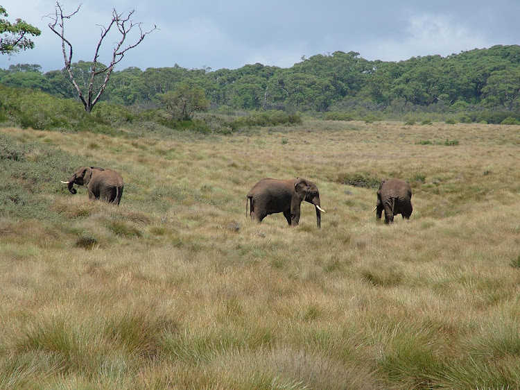
The government has halted the issuance of permits in key wildlife conservation areas to curb the dramatic decline of iconic species.
In a directive from the Executive Office of the President signed by the Head of Public Service Felix Koskei, Nema will no longer issue license and permits in Kajiado, Machakos, (Athi-Kapiti Corridor), Narok, Laikipia, Taita Taveta and Baringo areas.
Koskei said the issuance of licenses will stop until a conservation policy has been done.
“In a meeting between HE The President and the wildlife conservation players, land management matters (ownership, adjudication, change of user) in Kenya were flagged out as some of the issues affecting sustainable wildlife conservation and management in the country,” Koskei said in a letter dated July 24.
The letter is addressed to Tourism CS Peninah Malonza, Lands CS Zacharia Njeru and Environment CS Soipan Tuya.
Kenya is endowed with an extraordinary wealth of mammals, birds and other biodiversity.
There is however growing evidence of escalating wildlife loss, with a drastic decline of wildlife populations between 1977 and 2013 – on average by 67 per cent.
The declines have been attributed to rapid growth in human population and associated pressures on resources due to land use change, infrastructure development, and poaching.
To arrest the situation, the state has directed the National Environment Management Authority to halt any issuance of licenses and permits to protect the iconic species.
Koskei says to address the challenges threatening country’s iconic species, some of the presidential directives must be implemented with immediate effect.
The directive stops any further land subdivision and change of land use in the specified areas.
Lands ministry has also been tasked with fast tracking of Community Land Act.
A review of National Land Use Policy and the Physical and Land Use Act 2019 will be done to include conservation as land use category in the country.
“All MDAs (Ministries, Departments, and Agencies) responsible for various issues identified above to form a multi-sectoral team to formulate and implement the country’s conservation policy to be spearheaded by the state department for wildlife.”
Koskei will be updated through periodic progress reports.
One of the directives is to implement the 2016 Wildlife Corridors and Dispersal Areas Task Force Report with Athi-Kapiti Corridor as a high priority area.
Wildlife migratory corridors connect core habitats and are critical for species’ survival and long-term viability of ecosystems.
In the African savannah, animals disperse or migrate across landscapes in response to intrinsic factors (for example breeding); external or environmental factors such as drought, floods, diseases, fires, to access vital resources such as pasture, water, breeding grounds; to reduce the risks of predation; and to enhance genetic health (mating), among others.
Migration is essential for sustaining resilience of large populations in the face of variable rainfall, which is highly correlated to availability and shortage of forage.
Connectivity conservation recognises the importance of physical connection and linkages between isolated habitats that increase the effective area available to wildlife.
In the assessment of wildlife dispersal areas and migratory corridors, the conservation connectivity framework was used a variety of data sources, scales and analyses in the context of inclusiveness and collaborative stakeholder involvement.
The datasets included remote sensing maps on land cover/use, sample and total counts from low-level aerial surveys, ground counts, wildlife collar tracking, expert knowledge, and interviews with key informants.
Geotechnologies were used for spatial analysis and modeling.
Specific wildlife habitats were characterized and defined based on the drivers, pressures, state, impacts and responses framework to understand socio-ecological and economic interactions as they relate to resource planning and decision-making, as well as to prioritize opportunities, threats and desired actions.
A total of 58 migratory routes and corridors were identified in the southern Kenya rangeland ecosystems: Maasai-Mara ecosystem (17); Eburu Forest and Lakes Naivasha-Elmentaita-Nakuru conservation and ecological area (8), Athi-Kaputiei and Nairobi National Park (7), South Rift (8), Amboseli and west Kilimanjaro (8), and the Tsavo Conservation Area (10).
Fifty-two migratory routes or corridors were identified in the northern Kenya rangelands and coastal terrestrial ecosystems.
Almost all the wildlife dispersal areas and migratory corridors in the Kenya rangelands have been interfered with by human activities to an extent; some are highly threatened or have been completely blocked.
For example, the collapse of wildlife populations in the Athi-Kaputiei area and subsequent curtailment of their movement from the Kajiado plains into Nairobi National Park has been attributed to high-density settlements, fences and subdivision along the Kitengela-Namanga highway.
The main threats to habitat connectivity are incompatible land use in wildlife areas, including expansion of crop cultivation along the rainfall gradient, high-density settlements, fences, mining and quarrying, woodland clearing, wetland drainage, high-density livestock presence, and poaching.
The task force report has been catering dust in government shelves.