The Kenya Meteorological Department said showers will
increase from Saturday and Sunday, reaching more regions.
“Rainfall is expected to continue in some parts of the highlands east and west of the Rift Valley, the south Rift Valley, the
southeastern lowlands, the Coast and Northeastern Kenya,” the department said.
Highlands west of the Rift Valley comprise Siaya, Kisumu,
Homa Bay, Migori, Kisii, Nyamira, Trans Nzoia, Baringo, Uasin Gishu, Elgeyo
Marakwet, Nandi, Nakuru, Narok, Kericho, Bomet, Kakamega, Vihiga, Bungoma,
Busia and West Pokot.
On the other hand, the South Rift Valley comprises Narok and
Kajiado.
The forecast shows while rains have been limited in
recent days, they will begin to increase from the weekend.
For western Kenya and Rift Valley regions, rain is expected
to pick up gradually and become more frequent between Saturday and Monday.
Farmers should expect more regular rain starting
this weekend, especially in the afternoons and evenings.
In Nyandarua,
Laikipia, Nyeri, Kirinyaga, Murang’a, Kiambu, Meru, Embu, Tharaka Nithi and Nairobi,
the rains will increase after a few dry mornings.
In Marsabit, Mandera, Wajir, Garissa and
Isiolo, rains are expected to be more consistent through the weekend.
Even in the usually dry Kitui,
Makueni, Machakos, Kajiado and Taita Taveta as well as inland Tana River,
rains will start returning.
In Mombasa, Kilifi, Lamu and Kwale, including the
Tana Delta, light showers are expected to continue.
This renewed rainfall fits with the earlier monthly outlook,
which had warned that April would start slowly before rains strengthen later.
The country experienced reduced rainfall in late March and
early April, but weather experts said this was temporary.
Temperatures will remain high in some areas, especially in
the north and Coast, but the return of rain is expected to improve soil
moisture.
International climate experts are
predicting the return of El Niño later this year.
According to the latest update from the Climate Prediction
Center, there is a strong likelihood that the current weather patterns will
shift significantly, bringing a period of heavy rainfall and warmer
temperatures by the second half of this year.
The world has been experiencing La Niña for the past several
months, a phenomenon that often brings drier conditions to East Africa.
However, new data shows the ocean temperatures are
beginning to rise, and a transition to "neutral" conditions is
expected between now and July.
By the period of June to August, there is a 62 per
cent chance that El Niño will officially emerge, according to the US the
Climate Prediction Center.
Forecasters believe
this pattern will then persist through the end of the year, potentially impacting
the short rain season that typically occurs between October and December. This
shift is caused by changes in trade winds and water temperatures in the
tropical Pacific, which disrupt global weather.
El Niño years in Kenya are historically associated with
intense rainfall that can lead to flooding in low-lying areas, though it can
also provide a boost for hydroelectric power and water reservoirs.

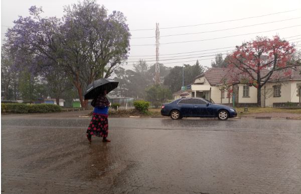 Rain on Kenyatta Road, Nyeri. Nyeri is among counties slated to continue experiencing heavy rains till the end of this month./KNA

![[PHOTOS] The new Ngong –Naivasha Road viaduct](https://cdn.radioafrica.digital/image/2026/06/64d4f771-4432-4aee-ba3c-2f304c4436ec.jpg)


![[PHOTOS] 'Mr Speaker Sir' Gen Z protester in court](https://cdn.radioafrica.digital/image/2026/06/b3e62d8e-25c3-4780-90f9-4eb48b1ce8a7.jpg)