 The report shows drier than normal weather.
Farmers hoping for rain in July are likely to be
disappointed after regional weather experts warned that most parts of the
country will remain drier than normal.
The drier-than-normal conditions are expected to continue
through August and September. Only parts of the Coast are expected to receive
meaningful rainfall.
The warning comes from the Igad Climate Prediction and
Applications Centre (Icpac), the regional climate agency that monitors weather
patterns across the Greater Horn of Africa.
It raises concerns for Kenyan farmers with crops still in
the field, especially in the western region.
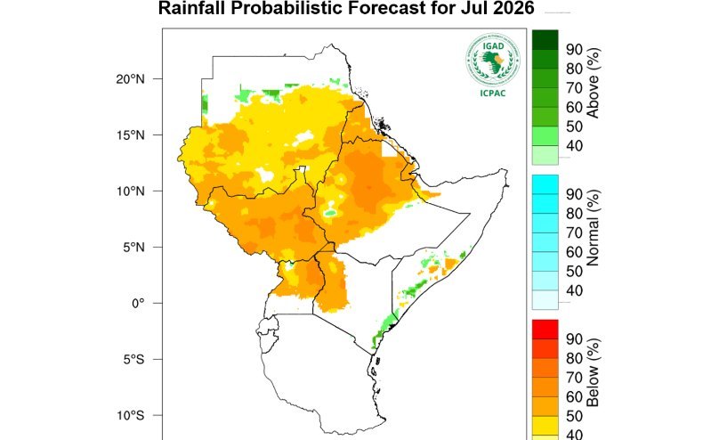
“High chances of drier than normal conditions in July are expected over most of the region. But an overall drier than normal conditions
indicated over most parts of the region from July to September, with wetter than
normal conditions expected over part of coastal Kenya,” Icpac said in its
latest forecast.
“The corresponding seasonal temperatures are expected to
be warmer than normal over most parts of the region.”
For Kenya, the forecast means that much of the country
could face another month of limited rainfall at a time when some farmers are
still nurturing crops planted during the long rains season.
The outlook is even more worrying because the dry spell
is not expected to end soon.
According to ICPAC's seasonal forecast covering July to
September, drier than usual conditions are expected over much of the region
including Kenya. The much-awaited El Niño rains will come in October.
The forecast suggests that farmers in western Kenya, one
of the country's key food-producing regions, may face moisture stress if the
dry conditions persist.
Crops that are still in fields could be affected, while
pasture and water sources may also come under pressure in some areas.
At the same time, temperatures are expected to remain
unusually high.
The latest regional forecast reinforces an earlier
warning issued by the Kenya Meteorological Department that the country faces
several dry months before the expected arrival of El Niño-enhanced rains later
in the year.
Acting director of Meteorological Services Edward Muriuki last month cautioned that June, July and August would largely be dry across
much of Kenya.
"The next three months will be largely dry before El
Niño rains arrive toward the end of the year," Muriuki said.
He noted that although there was an 80 to 82 per cent
chance of El Niño conditions developing during June, July and August, the
period would still be dry in most parts of the country.
Muriuki said, "The enhanced rainfall, common during
El Niño, would occur during the October, November and December seasons."
According to the Kenya Meteorological Department's
earlier June-July-August forecast, western Kenya was expected to receive
near-average to below-average rainfall.
The department also warned that most of the South-eastern
lowlands and Northeastern region are expected to be generally sunny and dry.
Nairobi and parts of the central highlands are expected
to experience occasional cool and cloudy conditions accompanied by light
rainfall, but not enough to significantly change the overall dry outlook.
The Coast remains the main exception.
Muriuki had earlier indicated that coastal counties could
receive near-average to above-average rainfall. ICPAC's latest forecast points
in the same direction, identifying coastal Kenya as one of the few areas where
wetter-than-normal conditions are likely in July.
The prolonged dry spell comes as scientists continue to
monitor the development of El Niño and the Indian Ocean Dipole, two major
climate systems that strongly influence rainfall in East Africa.
Muriuki explained that El Niño alone does not determine
Kenya's weather.
"The Met is also closely monitoring the Indian Ocean
Dipole (IOD) signal, which modulates the effect of El Niño in Kenya," he
said.
The Indian Ocean Dipole measures differences in sea
surface temperatures between the western and eastern Indian Ocean. A positive
phase is often linked to heavy rainfall in Kenya during the October to December
short rains season.
According to Muriuki, most forecasts suggest the IOD
could turn positive later this year.
"The combined effects of El Niño and a positive IOD
significantly influence rainfall patterns over Kenya, potentially leading to
enhanced rainfall during the October-November-December season," he said.
Instant analysis
The forecast of below-normal rainfall until September presents a major test for Kenya’s agriculture sector, particularly in western Kenya where many farmers still have crops in the field. Prolonged dry conditions could reduce yields, strain water resources and increase pressure on livestock-dependent communities. While the anticipated El Niño rains later in the year may improve conditions, the immediate concern is managing the gap between the end of the long-rains season and the onset of enhanced short rains. The warning also highlights Kenya’s growing vulnerability to climate variability and the need for stronger drought preparedness and water management strategies.


![[PHOTOS] Raila Odinga Stadium construction enters home stretch](https://cdn.radioafrica.digital/image/2026/06/45f6990c-4882-4cd2-b83c-8fc730dcdce5.jpg)
![[PHOTOS] Calm prevails in Kisumu, Homa Bay](https://cdn.radioafrica.digital/image/2026/06/dff8923b-c99a-4f40-a4be-cc996653e4e0.jpg)