

Weather warnings have been upgraded to amber for most of Scotland as Storm Floris bears down on the UK.
The warning lasts from 10:00 BST on Monday through to 22:00 and warns of danger to life as damage to buildings and trees due to storm conditions is expected.
There is also a yellow warning across northern England, north Wales and Northern Ireland from 06:00 BST on Monday through to midnight.
Storm Floris is the sixth named storm of the 2024/25 season, and the first since January.
The storm is yet to develop but there will be a rapid drop in pressure as the system nears British shores on Sunday night.
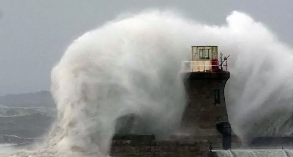
It is expected to bring "unusually strong" west or north-westerly winds to much of Scotland.
The amber warning covers a wide area as far south as the country's central belt - including Glasgow and Edinburgh and also the Highlands.
Gusts of 50 to 70mph are expected, even inland. Exposed coasts, hills and bridges could see gusts of 80 to 90mph, while some models have even suggested 100mph gusts which were last seen during Storm Éowyn in January.
The worst of the winds will be in the western coastal areas of the warning zone between late morning and early afternoon.
As the storm spirals away by late afternoon and early evening the strongest winds will move further eastwards to coastal areas of Aberdeenshire.
Trees are in full leaf at this time of year and are more likely to be toppled with branches broken off than during winter when the wind can whistle through them unimpeded.
Power disruption is also possible while heavy rain and flooding could be an additional hazard.
Scottish Transport Secretary Fiona Hyslop said a meeting had been held on Friday to ensure Scotland was ready for the storm.
"Given the unusual timing, and the fact some people will be on holiday, travelling or perhaps unaware, we are trying to raise even more awareness than usual of this potentially disruptive storm."
She added: "This is a slightly unusual situation for August, however the message is the same as winter - plan ahead, check your journey in advance, allow extra time and don't take any unnecessary risks."
National Rail has warned that speed restrictions are likely and warned journey delays and cancellations are possible.
Strong winds can also bring down trees that block tracks and damage power lines.
Scottish ferry operator CalMac has issued a series of cancellation warnings ahead of the storm.
In a post on X it said: "Disruption to sailings is expected across our network on Monday, August 4 due to forecasted strong winds across parts of Scotland's west coast."
Meanwhile, motorists are urged to slow down in poor weather and avoid exposed Highland and coastal routes.
Rod Dennis, from breakdown service RAC, said: "It's the height of the holiday season, so those towing trailers and caravans, as well as those with roof and tent boxes, must ensure their loads are properly secured."
Named storms in August are not that rare.
Last year, Storm Lilian struck the UK on 23 August just before the bank holiday weekend, closing stages at the Leeds Festival and cancelling Heathrow flights.
In 2023, Storm Antoni brought wet and very windy weather to south Wales and south-west England affecting events such as Brighton and Plymouth Pride. Less than two weeks later Storm Betty brought further disruption.
In 2020 there were also two August storms - Ellen and Francis - that the Met Office describes as "two of the most notable August storms in the last 50 years".
These two storms brought wind gusts of 79mph and 81mph respectively with transport disruption, coastal flooding and power cuts.
The storm follows the UK's fifth warmest July on record, according to provisional figures from the Met Office.
All four UK nations recorded one of their 10 warmest Julys, and July was the sixth consecutive month of above-average mean temperatures for the UK, the Met Office said.
The first day of the month brought the highest temperature of the year so far, with 35.8C in Faversham, Kent.


